


The West Philippine Sea (WPS) is home to a diverse marine ecosystem that comprises an estimated 30% of the coral reef in the country with its Kalayaan Group of Islands [1]. It also contributes to around 27% of the country’s commercial fisheries production [2], which serves as a crucial source to support the country’s economy and food security. The whole marine ecosystem has structures and functions that play a key role in the biogeochemical cycling of the life’s building blocks (nitrogen, carbon, oxygen, silica, and sulfur) and the overall biological productivity, all of which leads to ecological production of ecosystem services such as pollution control through carbon sequestration, habitat for many marine species, and shoreline stabilization and erosion control, among many others [3].
The ocean covers 70% of our planet that even ships alone cannot cover rapidly enough to provide a global picture. This is where the critical role of satellite remote sensing comes in. The appreciation of remote sensing on marine environment applications started as early as the 1970s with the promise of global coverage that matches the global nature of ocean processes [4]. With Earth observation satellites covering the Earth 365 days a year, it reveals vital information on changing patterns of behavior, especially those observed at the surface that impacts human activities. With our increasing ability to monitor the vast marine ecosystem, we can maximize our technological resources to protect the ecological integrity of the marine environment amidst the changing climate and man-made impacts.
The Philippine Space Agency, since its establishment in 2019, leverages previous research activities that demonstrate our capability to mobilize space data to address national security and development, and hazard management and climate studies. One of the PhilSA’s current initiatives is to understand the ecological and economical functions of the WPS, a region that comprises ~40% of the whole maritime domain of the country. Through the utilization of space-borne data complemented by ground measurements, the PhilSA aims to look at key variables of the marine environment such as chlorophyll-a to measure ocean productivity, sea surface temperature to study the interaction between the ocean and atmosphere, and sea surface salinity. Weather conditions are also monitored through cloud imagery over relevant areas in the WPS.
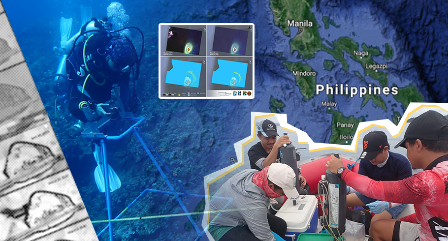
The PhilSA, in coordination with the Space Technology and Applications Mastery, Innovation and Advancement (STAMINA4Space) Program, the Advanced Science and Technology Institute (ASTI) of the Department of Science and Technology, and the Institute of Environmental Science and Meteorology (IESM), is collaborating with the UP Marine Science Institute (UP MSI) to better understand the changes and critical processes in the WPS using relevant satellite-based information. Here we explore the added value of satellite imagery to complement the on-site data collection focusing on physical, chemical, and biological research. Satellite data with varying spatial resolution was used for different applications, from change detection to habitat mapping, for a wider scale perspective of the different key features in the WPS. Moving forward with the research collaboration, we pose several research questions that ultimately aim to shed light on the ecological processes in the marine environment and impacts of man-made influences across time. For now, we highlight several applications of satellite imagery, alongside in situ observations, to emphasize uses on change detection, coral reef monitoring, and biophysical parameter assessment in Pag-asa Island, Lawak Island, and Ayungin Shoal respectively. We maximize the use of readily available images and other high-resolution images to extract critical information of WPS features at varying scales.
Historical data for change detection
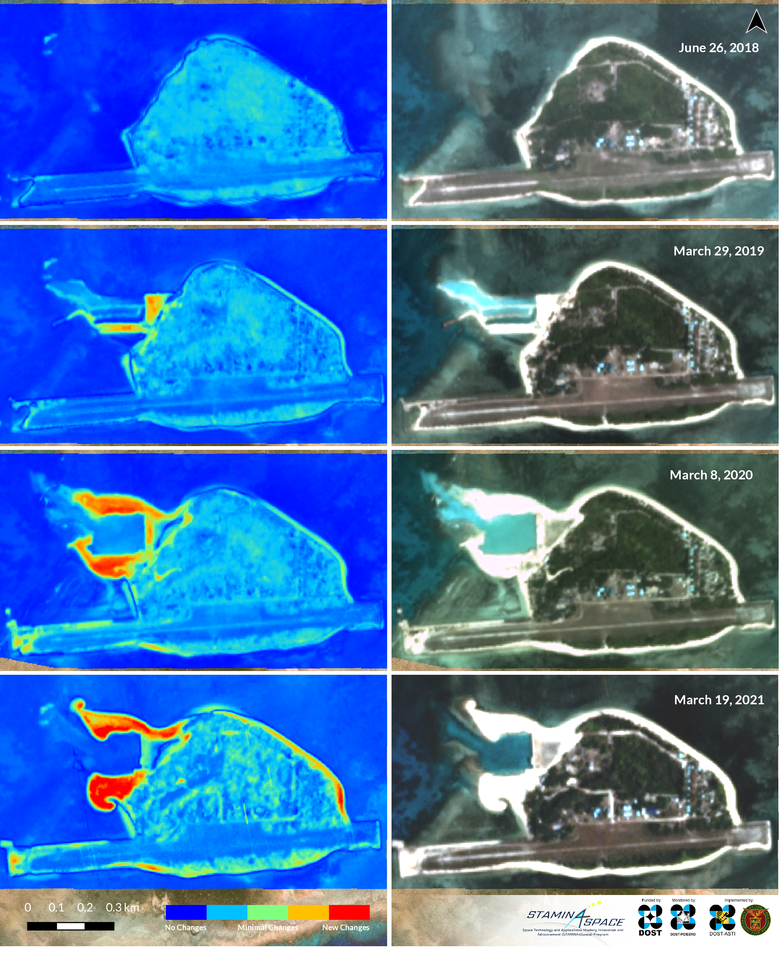
Figure 1. High-resolution satellite images of Pag-asa Island highlighting the yearly changes associated with island developments ( e.g. port construction and airstrip repair), visible from space from 2019 to 2021 (earliest reference date 2017 and latest available date in 2021).
Image source: Planet
Image processing: STAMINA4Space
The added value of satellite information is demonstrated in its ability to capture images of the same location regularly. Utilizing the historical data from daily Planetscope images allows us to easily detect the changes in features of an island at a larger scale, compared to using ground information alone. With satellite imagery, never-before-seen images from this perspective show the extent of changes in built-up features. At a finer resolution of 3m, satellite images allow for easier identification of the island’s distinct features as seen in Figure 1. Reclaimed areas have expanded in the past years as the island gets modified to accommodate the increasing presence of human activities. In particular, we are able to see the progression of port construction and airstrip repair. Having a better view of the changes allows us to not only efficiently monitor these developments and changes, but it also provides us with a quicker and a more proactive approach in evaluating infrastructure development projects in the area. In addition, the potential impacts of reclamation on the coastal ecosystem can be further investigated using satellite data.
Classification of benthic habitats
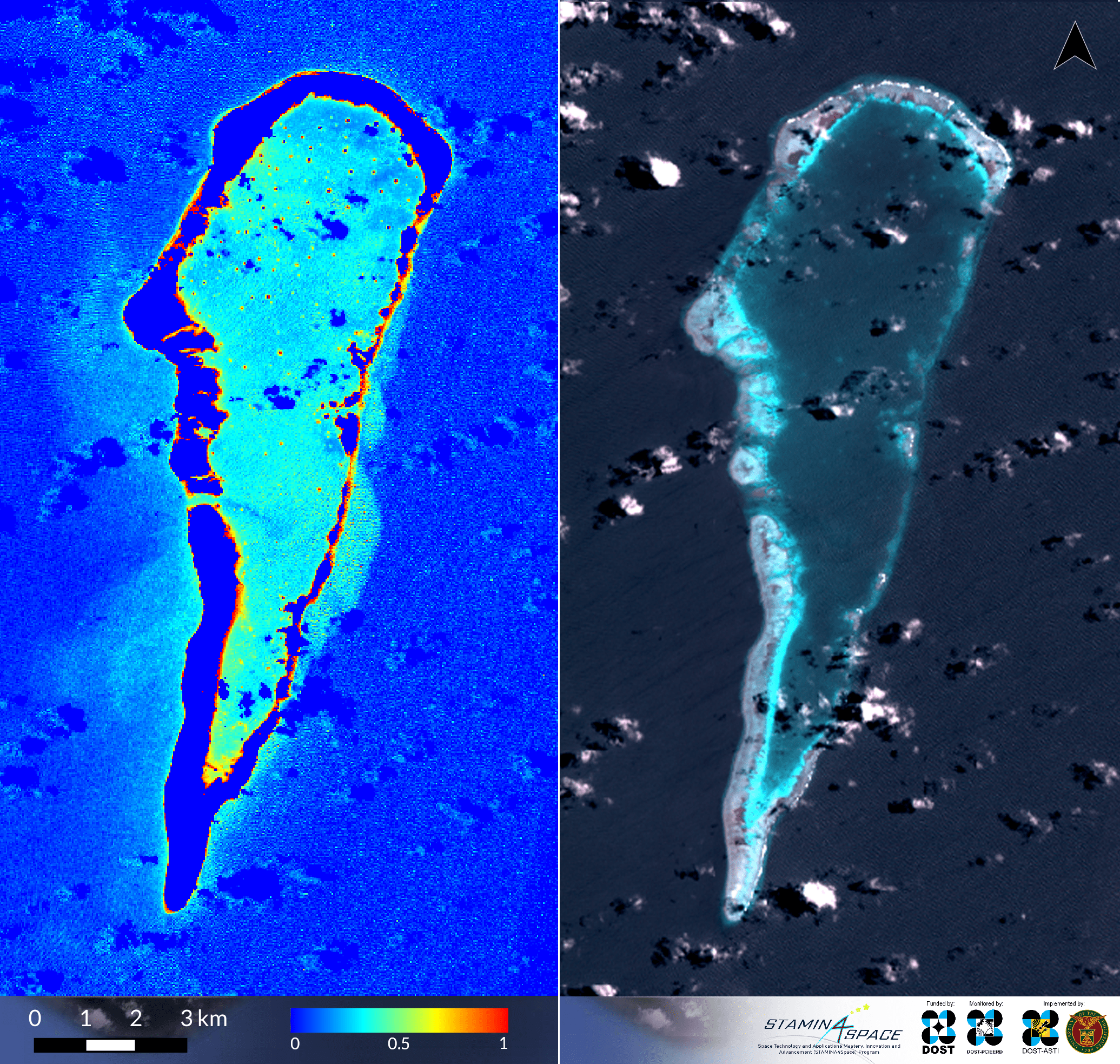
 (a)
(a)
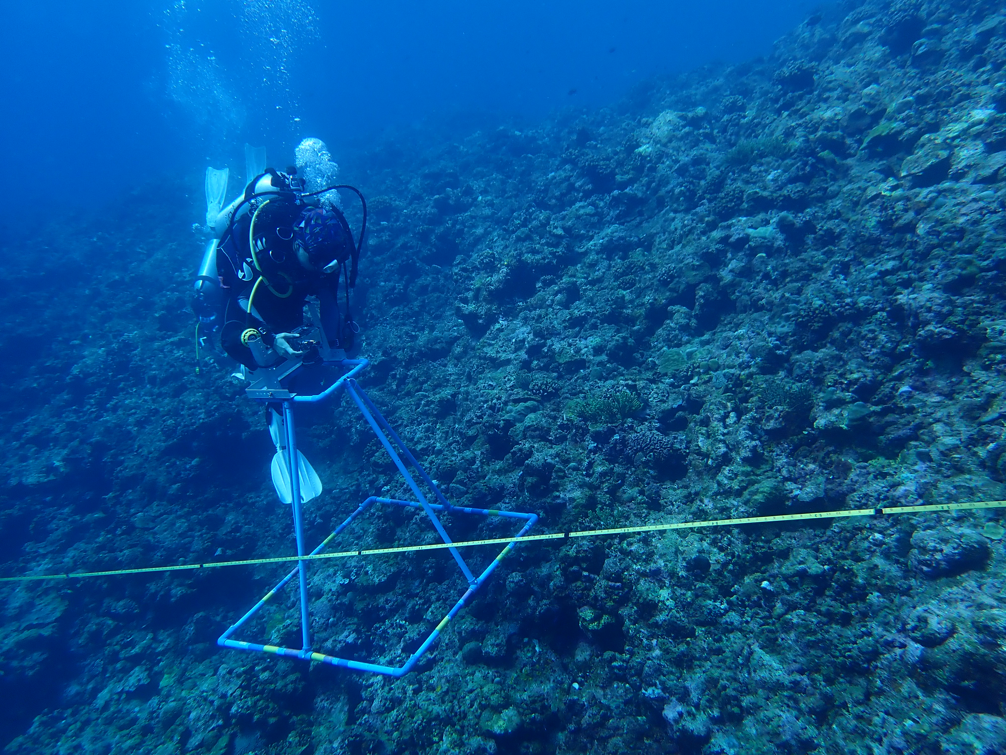 (b)
(b)
Photo courtesy of Dr. Wilfred John E. Santiañez
Figure 2. a) Lawak Island benthic habitat maps derived from Diwata-2 High Precision Telescope (HPT) images at 5m (left) cross-referenced with PlanetScope images at 3m (right). Different features are color coded to show distinction among seagrass (green), corals (yellow), bare (pink), shallow water (light blue), and deep water (dark blue); b) One of the examples of an on-site survey is a benthic survey of the coral reefs, conducted along a transect line with a camera mounted on a tetrapod to take actual photos of the benthic cover. This particular survey was conducted in Pag-asa Island taken on April 28, 2021 by Dr. Wilfred Santiañez.
Collecting field information in the marine environment can be very challenging due to additional constraints related to the actual collection on site and logistical concerns of field campaigns. The availability of high-resolution images led to an increase in the use of remote sensing approaches in studying coral reef habitats [5], as finer scales characterize reef features and allow observation of important events such as bleaching at a far distance. At larger scales, benthic habitat maps can provide insights in classifying the extent of different reef communities.
The Philippines’ microsatellite, Diwata-2, provides finer resolution images at 5m using its High Precision Telescope (HPT) to generate classification maps (Figure 2a). Through satellite tasking, as Diwata-2 passes the area of interest, the camera can be pointed to acquire images of the specific key sites. Here, we were able to focus on Lawak Island, located east of Pag-asa Island. Simultaneously, PlanetScope images at a higher resolution of 3m were utilized to generate similar benthic habitat maps for cross referencing. The Diwata-2 classification map agrees with the PlanetScope with identified seagrass beds surrounding the island within its shallow waters, and coral reefs parallel to its shore. This demonstrates our capability to derive benthic habitat maps from high resolution data such as from Diwata-2.
Validation using on-site data collected from benthic surveys is necessary to improve accuracy and to create a reliable map (Figure 2b). Collaboration with UP MSI researchers conducting the field survey strengthens our understanding of these important features at various scales. Matching information between field data and remotely sensed images is key to ensuring consistency in the validation of the classification maps. This combined approach of on-site and remote information further provides an efficient assessment of the potential impacts of natural and man-made factors on ecologically and economically important areas in the WPS.
Assessing the spatial variability of biophysical parameters
 (a)
(a)
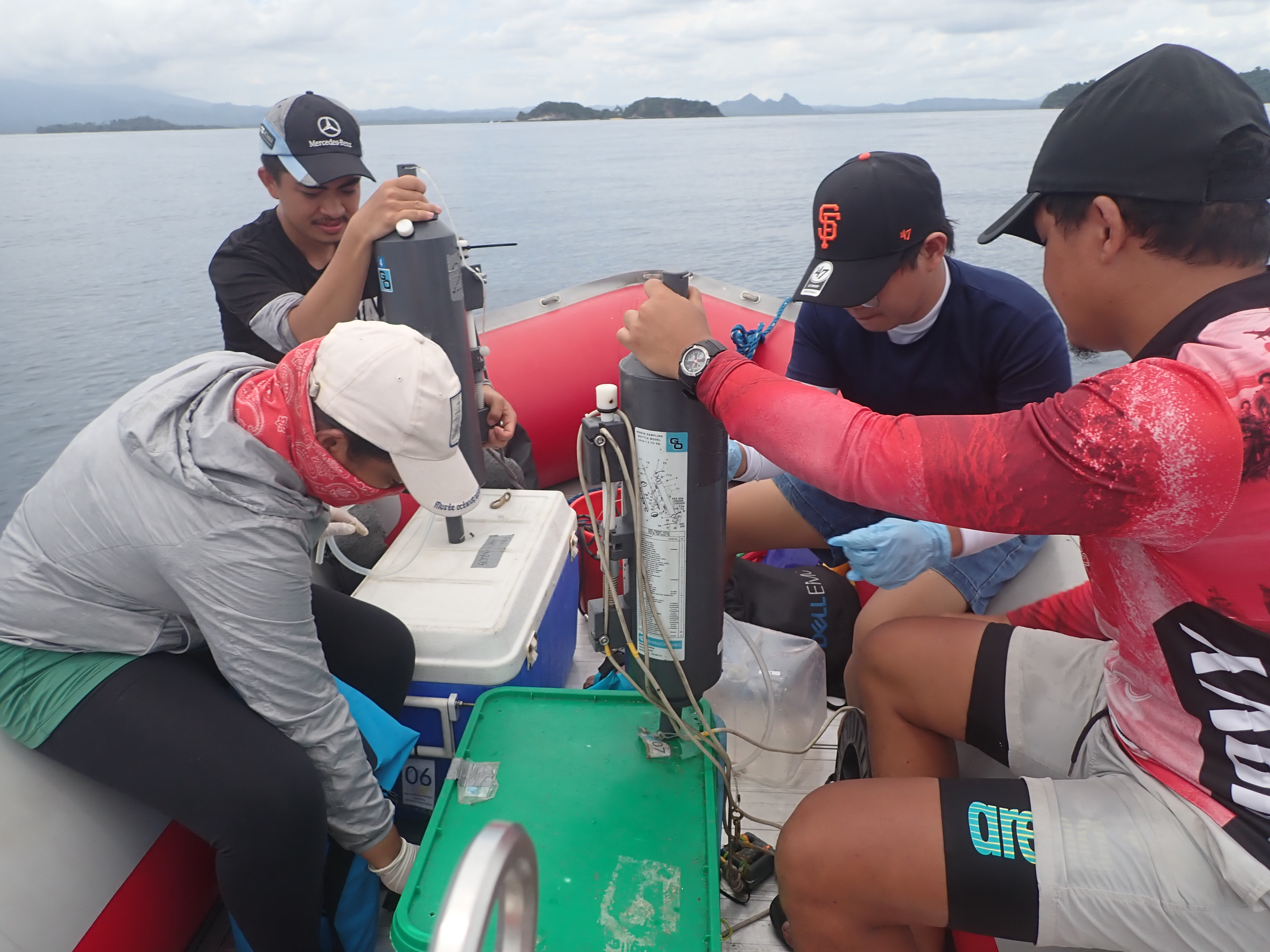 Photo courtesy of Adonis T. Gallentes
(b)
Figure 3. a) Chlorophyll map from a medium-resolution image (Landsat-8) and corresponding Truecolor or RGB image show Ayungin shoal in different perspectives. b) In situ water sample collection by the UP MSI Expedition Team in Quezon, Palawan using Niskin bottle sampler, taken on May 8, 2021.
The importance of understanding the biological processes in the ocean cuts across several aspects, from managing fisheries to mitigating the impacts of harmful algal blooms. Through satellite imagery, we generate maps to look at the spatial variability of important parameters such as chlorophyll, which can be used as a proxy to assess water productivity. Here, we use multispectral 30m resolution images from Landsat-8 to estimate chlorophyll-a values. Higher chlorophyll-a values are generally observed in the inner part of the shoal, especially in shallower areas (Figure 3a). The higher chlorophyll-a values may be associated with higher productivity in these regions. With these spatial variability maps, we can prioritize areas for investigation and also confirm the information using water samples collected on site.
Satellite-derived parameters and products have uncertainties or errors. Global products such as chlorophyll-a are usually calibrated using ground data acquired from the US and European waters. However, the water characteristics in those regions may differ from our coastal waters, which may prompt a regional calibration for a more accurate product. More calibration points can represent the Western Pacific region, where coastal waters can be influenced by processes such as tectonics, exposure to waves, winds and ocean currents, tidal range and intensity of current, supply of sediment and its transport along the coast, and coastal climate [6]. Different water classes must be considered to further account these similarities and differences in coastal water properties. The data collected by the UP MSI during their expeditions add valuable sampling points for validation and calibration, which can improve the accuracy and reliability of the satellite-derived data products.
The PhilSA continues to work closely with MSI through integrated analyses of satellite and ground data for more robust understanding of the key variables of the marine environment. Outputs from the collaboration reinforces the added value of satellite imagery in complementing ground information, and most importantly, opens up new research opportunities. With calibrated satellite data, we can further look at the trends and variability of biophysical parameters to gain more insights on the oceanic processes in the WPS. This vital information can then be mobilized to address environmental concerns and climate change impacts as we come up with efficient approaches in managing and ensuring the sustainability of our marine resources.
References:
[1] Ong, P.S., Afuang, L., Rosell-Ambal, R.G. 2002. Philippine biodiversity conservation priorities: a second iteration of the national biodiversity strategy and action plan. Quezon City, Philippines: Department of Environment and Natural Resources – Protected Areas and Wildlife Bureau, Conservation International Philippines, Biodiversity Conservation Program – University of the Philippines Center for Integrative and Developmental Studies, and Foundation for the Philippine Environment. 113p.
[2] Pauly, D., Liang C. 2020. The fisheries of the South China Sea: Major trends since 1950. Marine Policy, 121.
[3] Barbier, E. 2017. Marine Ecosystem Services. Current Biology, 27.
[4] National Research Council. 2011. Assessing the Requirements for Sustained Ocean Color Research and Operations. The National Academies Press.
[5] Eakin, C., Nim C., Brainard, R., Aubrecht, C., Elvidge, C., Gledhill, D., Muller-Karger, F., Mumby, P., Skirving, W., Strong, A., Wang, M., Weeks, S., Wentz, F., Ziskin, D. 2010. Monitoring Coral Reefs from Space. Oceanography, 23(4), 118-133.
[6] Inman, D. L., 1994. Types of coastal zones: similarities and differences. In K.F. Turekian and D.F. Boesch, chairmen. Environmental Science in the Coastal Zone, National Research Council, 67–84.